PROJECT HISTORY
The idea of transforming the old DL&W rail corridor into a ribbon of green along the Buffalo River is not new, but the momentum to make the vision a reality is.
Based on previous planning studies and proposals, beginning in 2017, the Western New York Land Conservancy undertook an extensive visioning process across the three neighborhoods surrounding the corridor – the Old First Ward, Perry, and the Valley. The resulting Community Vision Plan clarified how opening the corridor up for public use could transform it into a place where communities easily and safely access restorative natural spaces. Community members envisioned The Riverline as an inspiring community gathering place alive with the history and voice of the surrounding neighborhoods. More than just a trail, the reimagined rail corridor could become a vibrant, safe, and welcoming space for people of all ages, abilities, and backgrounds to connect with each other, with nature, and with the waterfront, throughout the year. Residents saw how The Riverline could become the focal point of a revitalized community and a restored ecosystem.
.jpg)
Artwork by Hiroaki Hata
In 2018, The Land Conservancy launched an International Design Ideas Competition for The Riverline’s design. The competition received 100 corridor design ideas from teams all over the world, including every continent except Antarctica. Thousands of people helped select community choice award winners and a juried competition helped to highlight elements that would become priorities for the project moving forward.
Over 1,000 people from the community gave their input during the Design Competition
In 2019 the Land Conservancy, in partnership with community members, local organizations, the University at Buffalo Regional Institute, and Make Communities began work on an Equitable Development Framework for The Riverline. Completed in 2020, this document is a framework to promote equity in all aspects of the project—working to ensure that all residents, regardless of race, ethnicity, income, age, or ability can benefit from investments in The Riverline and nearby neighborhoods.
In 2020, The Riverline was selected for inclusion in the High Line Network, a community of infrastructure reuse projects throughout North America. Together, Network members explore how to create a world where people have access to vibrant public spaces that center local communities, build civic connections, support environmental resilience, and foster equitable community development.
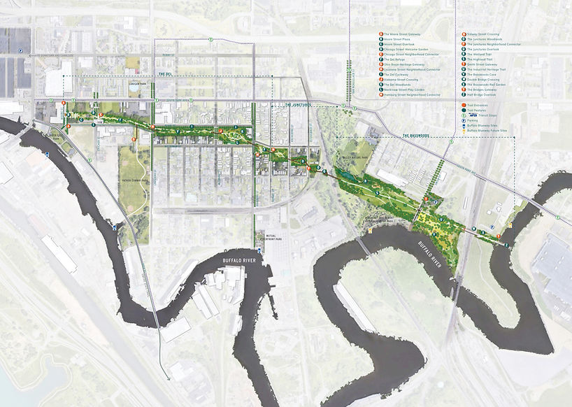
In 2020, the team of W Architecture, Hood Design Studio, and Green Shield Ecology were selected to lead the Concept and Schematic Design phase of The Riverline. This year-long process built upon the Community Vision Plan, design ideas competition, and Equitable Development Framework and additional conversations with the community to produce a concept for The Riverline as refuge, with a series of natural public spaces tailored to their surroundings. Finalized in the summer of 2021, you can see their renderings of various locations along the trail here.

conceptual design of The Riverline
In 2021, the project took another major step forward when the Land Conservancy hired Jeffrey Lebsack to be The Riverline Director. With Jeff at the helm, The Riverline now had a full-time staff person with significant experience guiding similar projects to fruition, whose job is dedicated to moving The Riverline forward.
In 2022, the project was awarded $900,000 in federal funds, thanks to the advocacy and support of our representatives in Congress including former U.S. Representative Brian Higgins and U.S. Senators Kirsten Gillibrand and Chuck Schumer. We also received $225,000 in state funding to use as a match for the federal funds thanks to the advocacy of former New York State Senator (now U.S. Representative) Tim Kennedy. This funding was used to develop preliminary designs and conduct an environmental impact assessment of the corridor, known as The Riverline Study. The Study was completed in October 2024 and you can find more information about it here.
In 2023, Molly Gadenz was hired as The Riverline’s Outreach Coordinator to develop and implement a variety of community-based programs, events, and other mechanisms for residents to get involved and give their input to help shape this great public space.

Community leaders and elected officials celebrate the release of federal and state funds for The Riverline. From left to right: former Old First Ward Community Center Director Patrick Gormley, former Old First Ward resident and CEO of Seneca Scientific Solutions+ Dean Seneca, former U.S. Representative Brian Higgins, U.S. Senator Kirsten Gillibrand, Land Conservancy Board Chair Kathy Bieler, former Land Conservancy Executive Director Nancy Smith, and former Mayor Byron Brown.